Topographic Mapping Note Sheet
What is topography?
Topography is the mapping of elevation or height.
What does a topographic map tell you, that other maps can't?
Topographic maps tell us elevation.
Who might use a topographic map?
-Oceanographic
-Geologists
-Pilots
-Marine Biologists
-Farmers
-Firefighters
Define the following:
Elevation: Height of a place relative to a reference height.
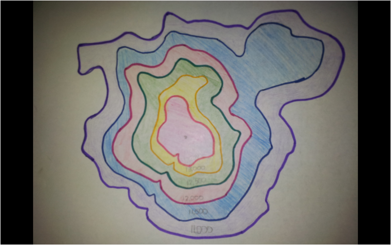
Contour Lines: A line connecting points that have the same elevation.
Contour Interval: The difference in elevation between two adjacent contour lines.
Depression Contour: Contour lines indicating a downward slope ( drawn with hatch marks ).
Bathymetry is topography in the Ocean
Topography is the mapping of elevation or height.
What does a topographic map tell you, that other maps can't?
Topographic maps tell us elevation.
Who might use a topographic map?
-Oceanographic
-Geologists
-Pilots
-Marine Biologists
-Farmers
-Firefighters
Define the following:
Elevation: Height of a place relative to a reference height.
Contour Lines: A line connecting points that have the same elevation.
Contour Interval: The difference in elevation between two adjacent contour lines.
Depression Contour: Contour lines indicating a downward slope ( drawn with hatch marks ).
Bathymetry is topography in the Ocean
Practice Questions:
1) Which of the topographic maps shows two peaks? Map C
Which side has higher elevation? The left side.
2) Which topographic map shows the steepest cliff? Map B
Where is it? On the right.
3) Can you tell the elevation of the topographic feature in plot B exactly? If so, what is the elevation, if not, why and what would be your closest guess?
No, we can't ell the elevation.
4) Which topographic map has a contour interval of 50 feet? Map A
5) Which of the topographic maps depicts a canyon, or depression? Map B
